Saturday, 18 May 2013

Would you like a little salt with that?????

The last time I did a trip one of the places I wanted to stop and didn't was The Bonneville Salt Flats.  Lots of tv commercials are filmed there, and when it dries out, lots of land speed records are attempted there as it is perfectly flat and extends for miles.

So a cool but clear morning riding the highway:


Not a bad way to spend your time eh???

I had originally planned to stop in Salt Lake City to try and get my laptop fixed, but by the time I got there I had decided to wait until Vancouver, and just use my tablet.  It turns out my tablet works fine for updating my blog, but for some reason it won't upload pictures... so I am currently on the hotel computer.  Oh well....

While stopped for lunch I figured I should find out exactly where the Salt Flats were, Wendover UT as it turns out, a mere 150kms away.  So bundled up against the cold and impending rain I set off again.  The only thing between me and my destination is a WALL of clouds from the road up, and you can see beyond it is sunny through it.

It was BY FAR the worst weather I have ever ridden through.  It was about 5 miles deep, HIGH winds, rain, hail, and just as I was entering it....lightning!!!!  I have never had wind try to push me into the road before!!!  I could see the clearing on the other side, so just kept going.... the weird thing was my gps didn't work the whole time through!!!!

This is what it looks like from the other side:


Only about 2 miles through the storm is my destination, still quite windy, but sunny!!  Unfortunately with the storm just going through, it wasn't so much The Bonneville Salt Flats, as The Salt Lake!!!  So I will attempt to go back tomorrow morning and hopefully it has dried out some what.

The nearest town as I said is Wendover Utah, so riding in it looks just like any other small town.  Motel 6, Super 8 hotels etc.... then all of a sudden there is a sign for The Mandelay Hotel....  Isn't that a casino in Las Vegas I thought.... It turns out part way through Wendover is the Nevada state line, and EVERYTHING changes.  The Mandelay Casino, and The Nugget literally have their front door on the state line.  Following that are a dozen other casinos, very small Vegas like....   The price of gas also goes up 30 cents a gallon from a block ago too!

So I try the Mandelay and it turns out they are full, as are most of the other casinos.  So back into Utah, the one whole block back... and I am in my usual hotel, for half the price.  So by 6:30 I have taken a dip in the unheated pool(brrrrrrr!!!!!) warmed up in the shower, taken a walk through a couple of casinos, couldn't get out fast enough!!! and had dinner....

So a nice relaxing evening in watching some tv, then off again tomorrow for The Flats...

Friday, 17 May 2013

Oooops......

It's late so just a quick update.  It looks like my off road adventures today killed my laptop!!!!!  So i have to try and fix it, and/or figure out how to upload pictures using my tablet.

Tablet typing.....

OK here goes trying to do an update via my tablet.  I was able to download my photos to my tablet, and it even has a rudimentary photo editing software program on it.

So I left Crazy Horse a bit late, 10am, but the ride to Bryce Canyon was only 150km or so.  The road into the canyon passes through Red Canyon and the Dixie National Forest, so a nice scenic route to get there.  The road once inside Bryce is about 17 miles long.  If you are going I would suggest going straight to the end, then stopping at all the view points on the way back, as they are on the left hand side of the road.  Bryce is what I had hoped Zion was going to be like:


Also if you are going to go, I would suggest stopping at Ruby's restaurant just outside the entrance to the park.  Absolutely fantastic food, busy, since all the tour buses stop there, but well worth it!

At one of the viewpoints i was talking to a couple of guys riding Goldwings, one of them suggested I take hwy 12 out of the park, as it is tremendously scenic.  He also mentioned a ridge that runs through it.  So even though it was completely the wrong way I followed his advice.  I even found the ridge road he mentioned.  I can't believe he took the road I did as it turned out to be 60kms of off road.  Lots of washboard in spots, thus the broken laptop that sits in my top box!!!

The ridge is appropriately called Hells Backbone:


That bridge is Hells Backbone Bridge, right at the top of the ridge line, howling wind, with a HUGE drop off either side!!

So my little off road scenic route took 2 hours, by the time I was back to the highway!  By 6pm I stopped in Torrey, perfect timing, and a great couple of hotels...all full!!! One had just sold its last room to a biker standing in front of me!!!

So instead of being fat and happy, after a good dinner, ensconced in my toasty hotel room, I was barreling down the highway in the middle of nowhere at dusk, getting colder, and hungrier, and more tired by the minute.  Finally at 8pm I was in Selina in a hotel, 15 minutes later I was in the Mexican restaurant next door...

Thursday, 16 May 2013

To Zion!!

Today was a slow paced day, partly my choice, partly not.  I headed out from Page AZ after a lateish breakfast.  Lateish in the sense that as soon as I crossed the Utah border the time jumped forward an hour!  Apparently Arizona doesn't believe in Day Light Savings!!!

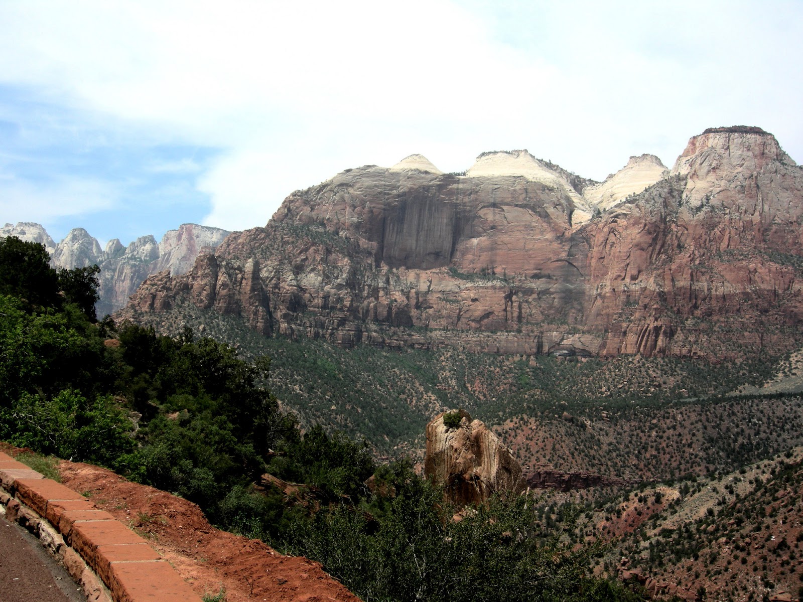
A light day riding, the first goal was to get to Zion National Park, a leisurely 200kms away.  Unfortunately most of the Japanese tourists that were in Antelope Canyon yesterday seemed to have headed to Zion today....huge bus loads of them.  That and the only road going in is single lane, and no passing allowed!  To be honest Zion was a bit of a disappointment.  The road isn't very long, or terribly scenic.  It does have a couple of redeeming points though: there is the longest tunnel I have ever been in in my life, 1.1 miles!!!  Very cool... and there is a brief stretch of road that does a bunch of switchbacks like The Moki Dugway.

The parking lots were COMPLETELY full, so after squeezing my bike into a parking spot with another bike I headed for the Visitors Center, also packed... By now it is after noon, the temperature is getting up there, so between the crowds and the heat I beat a hasty retreat.  By the time I got back to the main highway it was 2pm.  I had contemplated heading off to see Bryce Canyon, but my GPS tells me it is 100kms away.

I had passed through Kanab on my way to Zion and it seemed like a great little town, like an updated little village, with cool coffee shops and Victorian hotels.  One of the campgrounds just as you entered town was The Crazy Horse Campground!!!  Having already stayed in a Crazy Horse Campground I thought it was a sign I should stay here too!  So back to Kanab I headed leaving Bryce Canyon for tomorrow.  Hopefully it won't be very busy, and I already know the road going through it is longer than today.

A couple shots from today:


Wednesday, 15 May 2013

Rest Day.


Today was my first “rest” day in two weeks.  I think I spent a total of a half an hour on my bike.  To make up for that I spent 6 hours hiking!!!  Coming back to my previous comment about using Google to check the place you are going to visit, when I used Google Images for Arizona one set of photos stood out from all the rest.  A place called Antelope Canyon.  Actually there are two, Upper and Lower Antelope.  The ironic thing is when Matthew and I rode from The North Rim north, he back to central BC, and me on to Moab, we rode within 50 miles of here, and never knew it existed.  It is a slot canyon, formed in the sandstone by high speed water runoff causing fantastic abstract shapes in the reddish hued rock.

When I rode out to Monument Valley yesterday I rode right by the entrance to the Antelope Canyons.  Then further on up the road I rode by the entrance to a touring company called Adventurous Antelope Photo Tours.  So last night I looked them up on the internet, then called and made a suggested reservation for this morning.   It is not cheap, just under $200 gets you a 6 hour 4 Canyon tour.  Obviously just doing Antelope Canyon would be cheaper.

So after meeting my tour guide Nate, and my four fellow tourers we set off for Owl Canyon, Rattle Snake Canyon, Upper Antelope Canyon, then after a delicious Pizza Hut lunch our final stop Sheep’s Head Canyon.   Upper Antelope was crazy busy as there is a VERY small window when light beams stream into the canyon, so ALL the tour groups arrive at the one canyon from 10:30 – 12-:30.  The rest of the canyons we had to ourselves for the time we were there. 

Nate was fabulous, as he knew when each sun beam would be where and had our small group at each one about 15 minutes early so we all had front row seats for photo taking.  The tour guides toss sand into the air so you can see the sun beams more clearly.  Over the course of the day I took about 300 photos!  So to narrow it down to submit here was tough!!!  These are all exactly as were taken with the camera, not a single one has been “Photoshopped” in any way.  They are in order of the day:


Tuesday, 14 May 2013

One of the best riding days ever!!!


 This is why I ride an Adventure motorcycle!!  


With the exception of the heat this was definitely the best day I have ever spent riding.  After leaving Page AZ early this morning to escape the heat I traveled just over 200kms to reach Monument Valley:


Just north of Mexican Hat Utah you start the Trail of the Ancients, part of the National Scenic Byway.  Off Highway 261 there is a loop called Valley of The Gods, a nice twisty gravel road running through the wilderness:


Thanks to a couple days of off road training, even the thought of road biased tires didn’t put me off the route.  The bike handled really well, and fortunately I had left most of the luggage back in the hotel.

One word of advice: if you are ever going to visit a place, Google it, then check the Google images and follow the links.  One of the links I found when researching Utah and Arizona was a photograph of a place called Moki Dugway.  It is described as follows: “Caution – gravel road 10% grade with switchbacks for 2.5 miles speed limit 5 mph”!!!!!  After seeing the photo and reading that how can you not jump at the chance to ride it????  It ascends from the canyon floor to the top of the canyon in a VERY fast fashion.  I rode to the top, it is a good thing the speed limit is 5 mph, as I might have been zipping along at 6 or 7 mph!!!!!  At the top I turned aound and this is the view:


About a third of the way down is the viewpoint of the photo I had seen which gives you a good idea of the route:


After my descent back down to the canyon floor I set of for Comb Wash Rd., another dirt track running from hwy 163 to hwy 95.  Unfortunately it wasn’t very well marked so I missed the turnoff.  After realizing I had passed it I back tracked and set off down the road.  After a couple of miles I pulled over to check the distance to the nearest town on the other side.  I had a very limited margin for error with gas.  If the road was closed for any reason and I had to turn around I wouldn’t have enough gas to make it back to the nearest town.  So I turned around and left it for another day.

So another 200kms back to Page, back to the comfort of air conditioning!!!  So just over 650kms, and a few hours off road, with some of the best roads I have ever ridden on.  Does it get any better than that?????

Monday, 13 May 2013

Almost perfect, then deja vu...


Yesterday was an uneventful day, just blasting along the interstate.  After 700kms, and an ever increasing temperature, I pulled into a campsite slightly before my target.  As it turns out from continuing on this morning, 10 minutes further and I would have found a KOA, with a pool and internet!!  Instead I had no shade, and spent the night 100ft from the interstate.

When I did laundry a few days ago another motorcyclist had obviously used it just before me as he left two new sealed earplug sets in the dryer.  It was a higher end one that I had never tried before.  The earplugs are attached by a yellow cord, as they sit way further inside your ears, so you can pull them out.  Well I am now a convert, 100 ft from the interstate and I didn’t hear a thing!!  I am sure it isn’t necessary to wash and dry them before using...lol...

This morning I was up early and off.  I had camped just past The Petrified Forest, and just south of The Painted Desert.  So I set a route for Page Arizona, and although my GPS said to take hwy 89, I chose 87 which seemed more interesting.  So why do they call it the Painted Desert???:


So I casually rode on as I only had about 400kms to do today.  Not a bad way to spend your day riding down the highway:


Then all of a sudden it came to a screeching halt.  At 1:30 with about 30kms to reach Page, or about 20 minutes, the road was closed, and I had to detour.  282kms!!!!!  3 hours later I reached Page!!!!  I even went through Jacob Lake, where Matthew and I camped before heading to the North Rim of The Grand Canyon.  Oh and by the way if you wanted to go to the North Rim today, you can’t, the road is closed.  If you detour about 400 miles you can get to the South Rim!!!!  Of course it also turned out to be by far the hottest day I have had yet too!!

So I arrived in Page and was slightly disappointed.  I knew it was on the edge of Lake Powell, but it isn’t a lake community down by the water’s edge.  It is up on the top of the canyon, so much for a nice dip before dinner....

I have booked a hotel room for a couple of nights as there are quite a few places I want to see in the area.  So weather permitting it should be a nice break from all the highway miles.